

Robtrek
-
Innlegg
6 -
Ble med
-
Besøkte siden sist
Om Robtrek

-
Exactly my experience as well! Thanks for sharing this report. "Likevel klarte vi å finne en enkel rute over Tverrhalsen og helt frem til umerka vann 745. Her startet problemene. Vi fulgte «stien» på gpsen, men den var ubrukelig. Vi så rett inn i en klippeformasjon og i følge gpsen gikk stien rett over 10 meter høye vertikale vegger. Etter en del klatring, frustrasjon og bannskap hadde vi klart å forsere denne delen av ruta også, men det var ikke takket være hverken kart eller gps."
- 12 svar
-
- 2
-

-
Meanwhile, to my surprise I found a comment by @OttoStover that he wrote more than 10 years ago in our German outdoor forum and that basically answers my question. He hiked across the mountain pass between Sørfjorden and Paurohytta and he confirmed that in reality, the route runs far away from the trail drawing on the map. If you look at the screenshots from my navigational app at the beginning of this discussion, the ascent to Baurifjellet, according to Otto, would be closer to height 851 and 862, which is about 1 km north of the trail drawing and of my own route. The map shows a small emergency shelter between 851 and 862, and Otto's route at that time touched this shelter (I don't know if the shelter still exists). So the trail drawing on the map, unfortunately, seems to lead people away from a safe route and into rather risky terrain instead.
- 12 svar
-
- 2
-
-
Good info! I wrote to DNT Narvik with my question. The NAR19 in alltrails is just the same fictional drawing as the trail on Norgeskart or UT Papirkart. Unfortunately, if you follow that line, you'll end up stuck at the mountain pass between gorges and rock barriers, just as I did.
-
A friend told me that the DNT-book Til fots i Norge from the year 2000 lists Paurohytta-Sørfjorden as route #1515, however without giving any detail on where to cross the pass. The book just says that there are trail markings on the section between Paurohytta and Skogvatnet (which is the easiest stretch, where trail markings aren't really needed at all). So yes, might be a case of copying old and unverified information to new maps, and since few people seem to hike there, nobody really cares to update the map.
-
For sure, most of the region along these fjords is off-trail anyway. So I was wondering why this particular route would be shown on the map. I first suspected that this was maybe a traditional route of the reindeer herders, but when I actually stood on the ground it seemed to me that even for reindeer, the topographic relief there is not that trivial to navigate. In short, if many years ago somebody decided to put this dotted line on the map I suspect there was a reason for it and people at that time were likely regularly moving along that route - but once on the ground I just couldn't figure out where the routing up that pass would reasonably run to avoid the climbing sections. By climbing I mean rather unpleasant stuff with a high risk of injury in case of a fall, not just "using your hands to ascend some steep rocks".
-
 Robtrek endret sitt profilbilde
 -
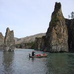
Who knows this trail - does it exist? On Norgeskart the route is shown as Sørfjorden - Baurifjellet - Skogdalen - Paurohytta. And in Paurohytta there is a large wall map also showing this trail, both as a red summer route and a blue ski route. I hiked there but could not find any trail. Old markings for snowmobiles do exist for the first 4 km (from Sadjemjávrre / Brynvatnet to lake 745). After that, I saw no markings. And the route shown on Norgeskart is not a real track but just a fictional straight line drawing which leads across impassable gorges and vertical rock barriers. The terrain is easy from the pass down to Skogvatnet and Paurohytta, but first one must go up the pass and that was quite difficult with 4 vertical rock barriers and some rather unpleasant climbing, a bit risky if you're hiking alone. So what about this trail shown so prominently on the map? If it exists, where in reality is the routing from lake 745 up to the mountain pass? I hiked along this route as part of a 5 week autonomous trek Rago - western Padjelanta - Hellmofjorden - Grunnfjorden - Mannfjorden - Sørfjorden - Nordkalottleden to Skjomdalen, and the pass between Sørfjorden and Paurohytta seemed to me, unexpectedly, the most difficult part of it all. Any information or background on this trail is welcome!


